
About Leavenworth County
Geography
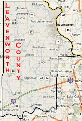
Leavenworth County is located in northeast Kansas along the Missouri River. Its cities include Tonganoxie, Leavenworth, Fort Leavenworth, Easton, Lansing, Basehor, and Linwood. Leavenworth County is bordered by Platte, Wyandotte, Johnson, Douglas, Jefferson, and Atchison counties.
Economy
Workforce
The Leavenworth County laborshed is an approximate 45-mile radius around the county which includes not only the metro areas but also parts of rural Kansas. The annual median household income in Leavenworth County is $63,435.
Housing and Commercial Growth
Median Home Value $165,800
Total Housing Units – 29,088
Percent Home Ownership - 67.4%
Median Rent - $762/month
Census Information
There are 78,797 people, 29,088 households, and 26,358 families residing in the county. The ethnic distinctions in the county are 85.0% White or of European origin, 9.6% Black or African American, 0.9% Native American, 1.4% Asian, 0.2% Pacific Islander, and 2.9% from two or more races. Those who identify themselves as Hispanic or Latino of any race are 6.9% of the population.
History
Leavenworth County was formed on August 30, 1854, from free territory, and it is among the first 33 counties formed by the first territorial government. Leavenworth County, as well as its county seat, was named after Henry Leavenworth, an officer in the War of 1812.
Visit the Leavenworth County Historical Society for more about the county's history, including information about its art, geography, commerce, people, and cuisine.