
Transportation
Transportation Network
3 interstates: I-70, I-35, I-29
4 interstate linkages: I-435, I-635, I-470, I-670
10 federal highways (including US 24/40 providing 4 lane traffic to KC)
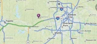
Driving Distance to Nearby Cities
| City | Distance |
|---|---|
| Kansas City | 30.8 mi |
| Overland Park | 32.2 mi |
| Lawrence | 14.5 mi |
| Leavenworth | 20.4 mi |
| Lansing | 20.8 mi |
| Topeka | 39.6 mi |
Air
The metropolitan area is served by 13 major
Commercial airlines and their connection partners.
These carriers offer over 200 daily departures, with nonstop jet service to 43 destinations.
A commuter carrier offers service to an additional 5 communities in the Midwest region.
Distances from Leavenworth County | Miles | Flight Time |
|---|---|---|
| Atlanta | 793 | 1:55 |
| Chicago | 501 | 1:20 |
| Dallas | 489 | 1:35 |
| Denver | 602 | 1:40 |
| Houston | 712 | 1:57 |
| Los Angeles | 1,580 | 3:40 |
| Minneapolis | 435 | 1:27 |
| New York | 1,221 | 2:45 |
| Orlando | 1,223 | 2:45 |